
Climate-Resilient Corridors
In addition to identifying linkage areas expected to facilitate climate-driven shifts in species ranges (i.e., climate-gradient corridors), the Working Group has also been exploring approaches for identifying linkage areas expected to continue providing connectivity as climate changes (i.e., climate-resilient corridors).
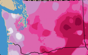
As part of this work, we recently completed an evaluation of the utility of future climate change projections for identifying climate-resilient corridors. Specifically, we developed fine-scale temperature and precipitation projections, and asked whether they could be used to identify the most resilient areas within Washington Connected Landscapes Project connectivity networks, i.e., those core habitat areas and corridors projected to see relatively little climatic change, thereby presenting good long-term connectivity conservation investments.
In the report below, we describe the methods used to develop our fine-scale climate change projections, summarize projected future climatic conditions for Washington, and then evaluate the utility of the downscaled data for connectivity conservation planning. Finally, we discuss the potential utility of projections obtained from “downstream” impacts models (models that translate climate changes to changes in other variables, e.g., fire severity).
Downscaled climate dataset available for download here.