Applying the Science
In our work to deliver high quality scientific tools and products to inform decisions that can impact habitat connectivity in Washington and neighboring habitats, we are interested in how organizations and individuals are applying and referencing this science. It is in this application that our products gain additional meaning, and where we can continue to learn.
Below are some examples of where our tools and products are being referenced and/or put to use to inform decisions:
1) A Wildlife Crossing Structure Feasibility Study for Interstate 5 Northern and Southern Linkage Zones was published November 2024. This document identified ideal locations for wildlife crossings in two linkage zones deemed critically important to landscape connectivity by previous WWHCWG analyses, including the recent Cascades to Coast Analysis, and provided conceptual designs and high-level cost estimates. The final feasibility study, above, was preceded by an Alternative Analysis report.
2) Washington Department of Fish and Wildlife provided least-cost corridors and Habitat Concentration Areas (HCA) layers to Bureau of Land Management to inform their Washington land management plan revision.
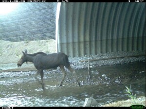
3) Habitat networks from the statewide analysis are being used to inform transportation corridor plans and mitigation strategies for highway improvement projects. To aid decisions on where to invest in highway improvements to benefit wildlife and improve safety (including WSDOT’s Environmental Retrofit or “I4” program), the statewide and Columbia Plateau habitat networks will be used, along with other information, to rank segments of the state highway network as high, medium or low priority for investing in habitat connectivity infrastructure. Monitoring of crossing structures in the I-90 Snoqualmie Pass East Project show wildlife’s successful response to habitat connectivity investments.
4) Model validation analysis for Greater Sage-Grouse provided genetic analysis of Greater Sage-Grouse in the Moses Coulee population that indicates this population is genetically distinct from the population on the Yakima Training Center (YTC) as there is little genetic exchange between the two populations. This finding emphasizes the importance of augmentation efforts for the YTC population informing work to maintain and recover this species.
5) Western Electric Coordinating Council requested statewide and Columbia Plateau connectivity layers for focal species habitat concentration areas and linkages, landscape integrity core areas and linkages, and climate gradient core areas and linkages for transmission planning.
We routinely update a more complete list for our reference as well. Please feel free to contact us with any questions, or to inform us of additional references and uses in the application of our work.
We welcome feedback from potential or current users of our products on how we can more effectively communicate and provide information to you to ease your use of our work.

